Welcome to the University of Iowa-hosted website for CPL
**TEST PAGE UNDER DEVELOPMENT June 18**
Cloud Physics Lidar Home Page
This site serves as a back-up to the primary CPL web site to allow access to CPL data when the main site is unavailable.
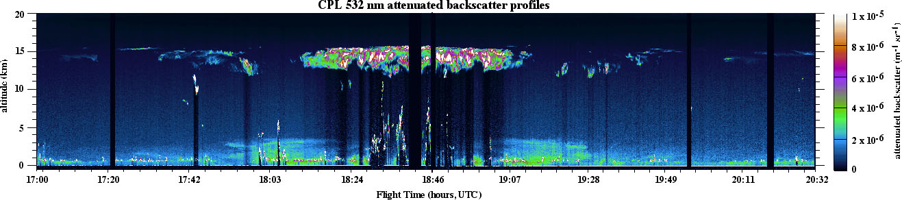
Example of CPL data. This image shows profiles of 532 nm attenuated backscatter obtained during the CRYSTAL field campaign from July 26, 2002. This image is representative of airborne lidar data, showing cloud height and internal structure (including cirrus, subvisual cirrus, low- and mid-level clouds, and multiple cloud layers) and boundary layer aerosol. In addition, a period of elevated aerosol, known to be Saharan dust, is evident in the middle of the time period.

The effect of clouds and aerosols on regional and global climate is of great importance. A long standing element of the NASA climate and radiation science program are field studies incorporating airborne remote sensing and in situ measurements of clouds and aerosol. These projects involve coordination of ground based and satellite measurements with the airborne observations. The goals of the experiments include testing satellite remote sensing retrievals, development of advanced remote sensing techniques and fundamental advances in knowledge of cloud radiation and microphysical properties. Active lidar profiling is especially valuable because the cloud height structure is measured unambiguously, up to the limit of signal attenuation.
The Cloud Physics Lidar is an airborne lidar system designed specifically for studying clouds and aerosols using the ER-2 High Altitude Aircraft. Because the ER-2 typically flies at 65,000 feet (20 km), its instruments are above 94% of the Earth's atmosphere, thereby allowing ER-2 instruments to function as spaceborne instrument simulators. The Cloud Physics Lidar provides a unique tool for atmospheric profiling and is sufficiently small and low cost to include in multi-instrument missions.
The Cloud Physics Lidar flies on the ER-2 along with other instruments and is typically located in the forward section of the wing superpod. A window in the bottom of the superpod allows the instrument to look directly at nadir (this is a non-scanning system).
The Cloud Physics Lidar provides a complete battery of cloud physics information. Data products include:
- Cloud profiling with 30 m vertical and 200 m horizontal resolution at 1064 nm, 532 nm, and 355 nm, providing cloud location and internal backscatter structure
- Aerosol, boundary layer, and smoke plume profiling at all three wavelengths
- Depolarization ratio to determine the phase (e.g., ice or water) of clouds using the 1064 nm output
- Direct determination of cirrus cloud optical depth (up to ~OD 3)
The CPL provides information to permit a comprehensive analysis of radiative and optical properties of optically thin clouds. To determine the effects of particulate layers on the radiative budget of the earth-atmosphere system certain information about the details of the layer and its constituents is required. The effect of clouds is often referred to as cloud radiative forcing. Cloud radiative forcing, in general, is the alteration that the presence of clouds has on the energy budget. The information required to compute the radiative forcing includes the vertical distribution of short wave cross section, a parameter that the CPL provides up to the limits of optical signal attenuation.
Using optical depth measurements determined from attenuation of Rayleigh and aerosol scattering, and using the integrated backscatter, the extinction-to-backscatter parameter can be derived. This permits rapid analysis of cloud optical depth since only lidar data is required; there is no need to use other instrumentation. Using the derived extinction-to-backscatter ratio, the internal cloud extinction profile can then be obtained.
The CPL uses photon-counting detectors with a high repetition rate laser to maintain a large signal dynamic range. This dramatically reduces the time required to produce reliable and complete data sets. The goal of the CPL analysis is to provide data within 24 hours of a flight including the cloud and aerosol quick-look pictures, cloud boundaries, and depolarization information. The optical depth determinations require more careful analysis.
Determination of optical depths for uncomplicated layers of cirrus clouds with homogeneous scattering characteristics can be completed within a day using an automated analysis algorithm. However, situations where the cloud layering and structure is complex, which often precludes an automated data processing algorithm, may require several weeks.